
1816 - from north to south. The street on the left side may be Nassau Street, the Street on the right is Chatham Street, later Park Row. The church in the foreground on the left is the "Brick Presbyterian Church", shorter "Brick Church". The old New York Times Building was later constructed on this lot. The church in the background is the St. Pauls Chapel, it is still there, maybe the oldest building in Manhattan. The green on the right side belongs to the City Hall Park. Here is a present google street view for orientation, same place, same direction:

Still in the present and another google street view, showing you the next station, before we return to past. We are on the south top of the city hall park, on the left side you see the Broadway, on the right side Park Row.


1822 - from south to north. On the left side the Broadway, on the right side Chatham Street (Park Row), in the middle the City Hall Park with the New York City Hall, at this point of time about ten years old. The Tower on the right belongs to "Brick Church". The large building on the right side (the sixth or seventh from total left) was the "Park Theatre", an early Manhattan theatre.

1825 - nearly same direction as the picture before. On the left side City Hall Park again and above it the tower of the "Brick Church". The Street is Chatham Street (Park Row) again. The large white house on the right side is the "Park Theatre". It was opened in 1798 and was used use as a theatre about 50 years. Like many other buildings its history endet with a fire.The Park Theatre burned down on the 18th of December 1848.
Here is a rare inside view of the Park Theatre:

Here is a rare inside view of the Park Theatre:


1831 - from north to south. You find the Park Theatre on the left side now. the street is Chatham Street (Park Row), In the background you can see St. Paul's Chapel, parts covered by plants from the City Hall Park on the right side.
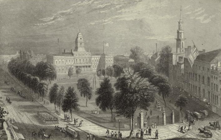
1830s - from south to north. The next picture was sketched while standing on a higher level, maybe the tower or the roof of the St. Paul's Chapel. Broadway on the left, the New York City Hall inside the City Hall Park in the middle and Chatham Street (Park Row) on the right side. The tower of the "Brick Church" is on the right side too and a flag hanging down from the pole on the roof of the Park Theatre.
1830s - from south to north. Next picture was drawn in the 1830s too. The left side is showing the City Hall and the park, on the right side the Park Theatre in blue-grey for the last time. The cute small building on the right side of the Park Theatre (on the 4th and 5th picture) has gone, there is a new structure with three floors now. Have a look at the foreground, there are two groups of old fashioned firemen on their way with their equipment.

1850s - southwest to northeast. We are watching onto the City Hall Park from a higher level again, maybe the roof of the "Astor House" or another structure in the neighboorhood. In the foreground left the Broadway, on the right side the tower of the Brick Presbyterian Church.


1851 - from north to south, the place almost the same as on the first picture. In the center of the picture we meet the "Brick Church" for the last time, it will be demolished 5 years later in 1856. It has been used as church, hospital, prison and office in the 90 years of existence. On the right side under a City Hall Park tree St. Paul's Chapel again.
The important detail on this picture is the building on the very left side, named "French's Hotel". This seven floors structure was build on the lot at the corner Chatham Street and Frankfort Street, where the famous second World Building will appear nearly 40 years later in 1889-1890. Watch at the buildings front, there is a sign, that let you know, that the place in front of the hotel is named "City Hall Square". Two years after the picture was taken, a murder case happened in the French's Hotel:
http://query.nytimes.com/gst/abstract.html?res=9802E2DB1131E13BBC4953DFB4678388649FDEThe next building in south direction was the "Tammany Hotel", headquarter of the Democratic Party, and behind it a couple of buildings used by newspapers: The Sunday Times, The New York Tribune and The Curier. So many newspapers on the same road caused the nickname "Newspaper Row".

1863 - another picture showing the Tammany Hotel, headquarter of the Democratic Party. It was torn down only a short time after the picture was made.
1860 - from west to east. This stereocard picture was taken on the 18th of June 1860 before the reception of the Japanese ambassadors by Mayor Wood and the Common Council of New York in the Governor's Room at City Hall.
City Hall on the left, many people in the foreground and in front of the City Hall, in the center of the pictures the "French's Hotel" and on the right side next to the tree the "Tammany Hotel".

1874 - southwest to northeast. Last picture is a birdseyes view again. Most of the picture's space belongs to the New York City Hall again. The light building on the right side is the wellknown "French's Hotel". The "Tammany Hotel" isn't part of the scenery anymore, on it's lot appeared a new building: "The Sun" took place at the Newspaper Row.

Sources: Google and friends, NYPL Digital Gallery and
Sorry about my bad English, I'm German.
Part 2 - First World Building and Potter Building
Keine Kommentare:
Kommentar veröffentlichen